Get to Know Your Watershed
A watershed is the land area that catches and contributes water to a water body. Water resources within a watershed are affected by what happens on the land within. Anything on the land can eventually impact the water resources.
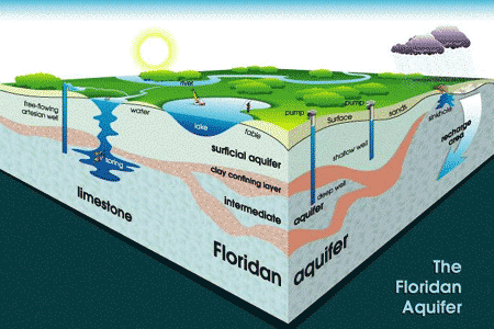
In Florida, surface water and ground water are connected due to the karst landscape. This type of landscape is also found in other parts of the U.S. Derived from the Slovenian kars (meaning rock), karst landscapes are underlaid by limestone that is easily dissolved by carbonic acid (water and CO2).
-
The Floridan Aquifer

Aquifers are underground rock and cave systems that hold water. The Floridan Aquifer is one of the most productive aquifers in the world, and the main source of drinking water in Florida and other areas of the Southeast. It is covered in varying thicknesses of sand, clay, and limestone, and reaches across southern Alabama, southeastern Georgia, southern South Carolina, and all of Florida.
Ground water in the aquifer is replaced by rainfall that soaks down through the soil (a process known as recharge), but this does not occur everywhere. Areas of high recharge include the well-drained sand ridges (most notably in the central and west-central parts of Florida).
Maintaining natural areas is critical for maintaining water supplies. The sand surface found in parts of the Southeast is porous, making it easy for water to flow through it and recharge the aquifer. Water cannot soak through the pavement that comes with intense development (parking lots, buildings, driveways, streets).
-
Springs

There are more than 200 springs in Florida, most emerging from cavities in the porous limestone of the aquifer to become part of the water system in streams, lakes, and rivers. Most Florida springs are found on the northern half of the state, and flow from the aquifer.
-
Lakes

The Southeast has thousands of lakes, large and small. In Florida, most of them were formed in the same manner as sinkholes. Ground water dissolved the underlying limestone, forming underwater cavities. When the roof of the cavities collapsed and formed a depression, they were filled with groundwater and rainwater. In addition to natural lakes, many man-made lakes are used for irrigation, mining, and aquaculture. Some lakes and ponds are designed to manage stormwater runoff from developed areas.
-
Rivers

The most common type of river in a karst region is a spring-fed river, where the limestone is close to the surface.
-
Wetlands

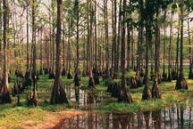
These are areas of land periodically covered by water and have many names, including swamps, marshes, and bogs. There is particular concern for the preservation of these areas because they perform many valuable functions for the state's ecosystem.
Wetlands provide habitat for fish and wildlife; improve water quality by trapping nitrogen, phosphorous, and other substances; intercept and slow down run-off; and protect shorelines from erosion and upland areas from floods.
-
How it All Connects
The connection between groundwater and surface water means that anything found in the surface water can find its way into the groundwater.
Water pollution occurs when a body of water is contaminated with the addition of materials and chemicals not intended for use. Because water plays a major role in creating diverse habitats and wildlife populations, pollution of water can impact biodiversity.


